
|
|||||||||||||||||||||||||||||||||||||||||||||||||||||||||||||||||||||||||||||||||||||||||||||||||||
|
|
||||||||||||||||||||||||||||||||||||||||||||||||||||||||||||||||||||||||||||||||||||||||||||||||||
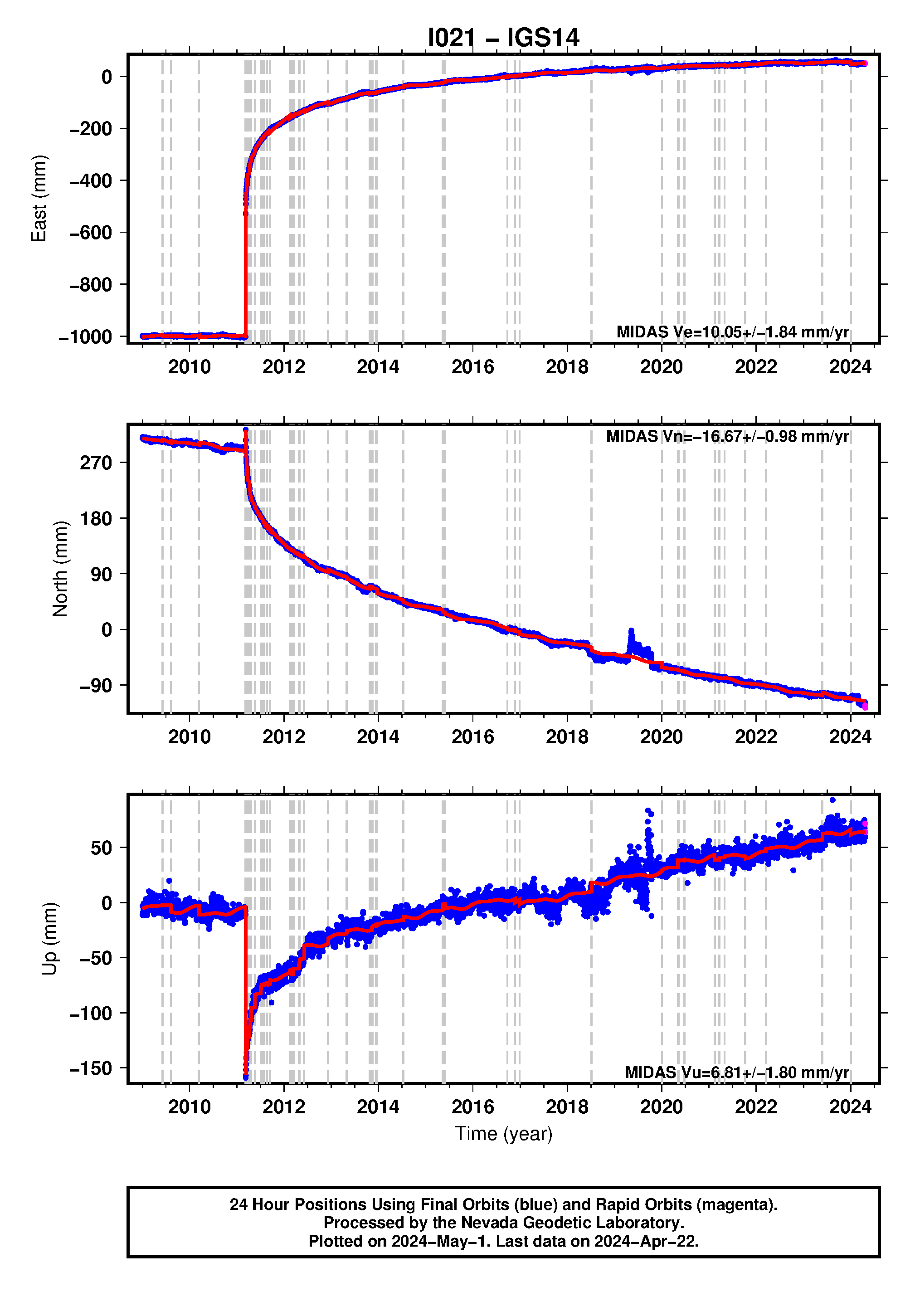
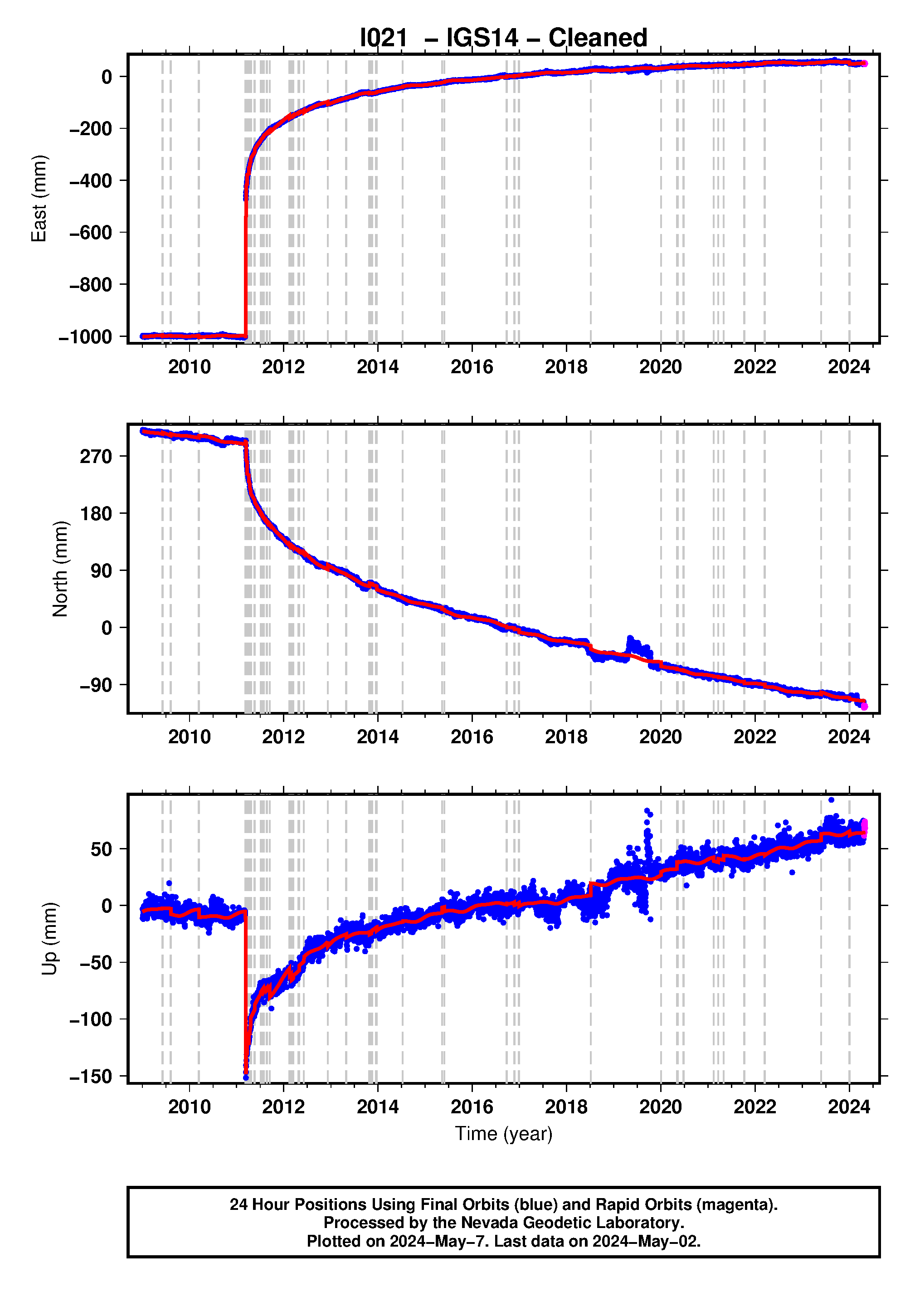
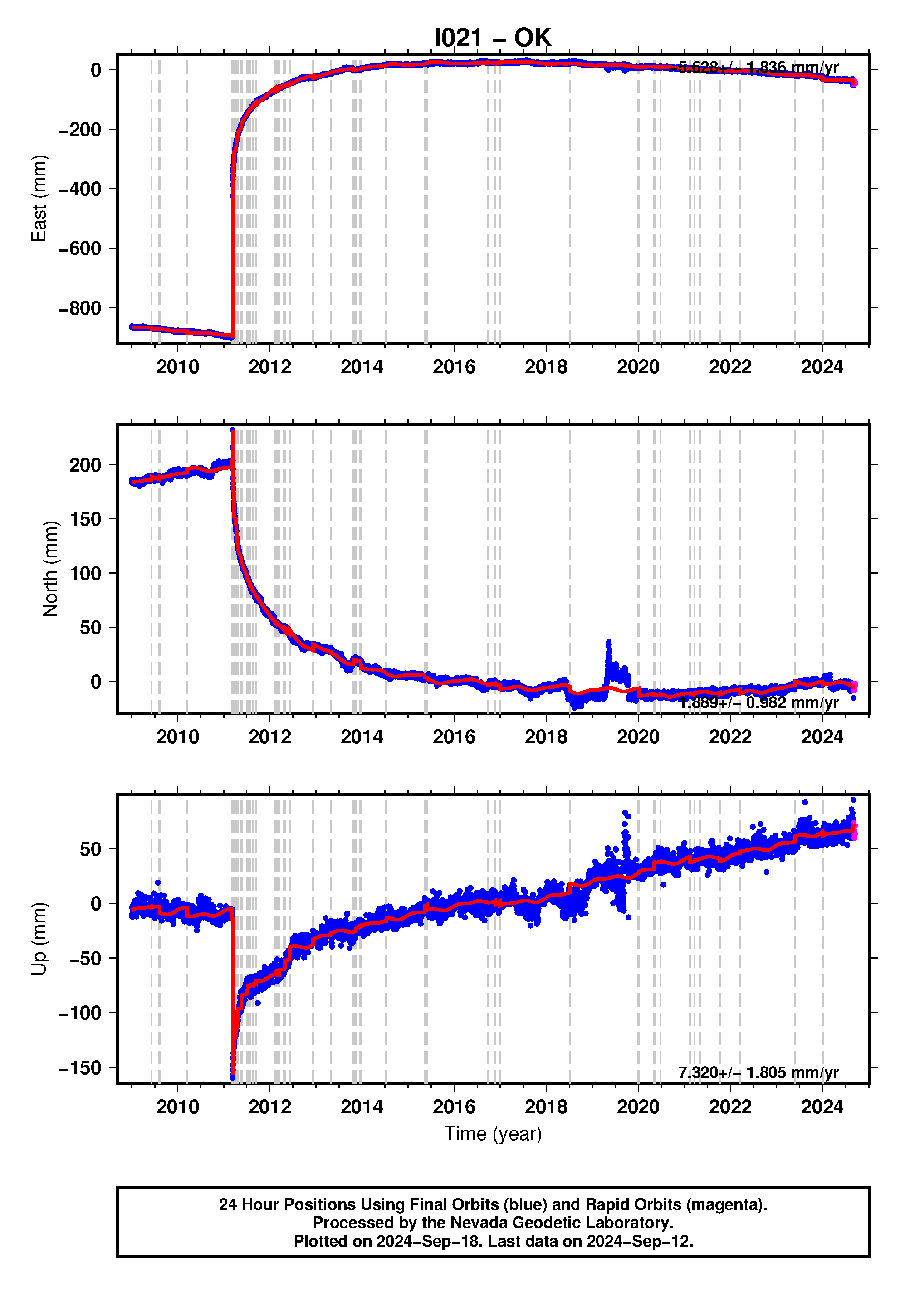
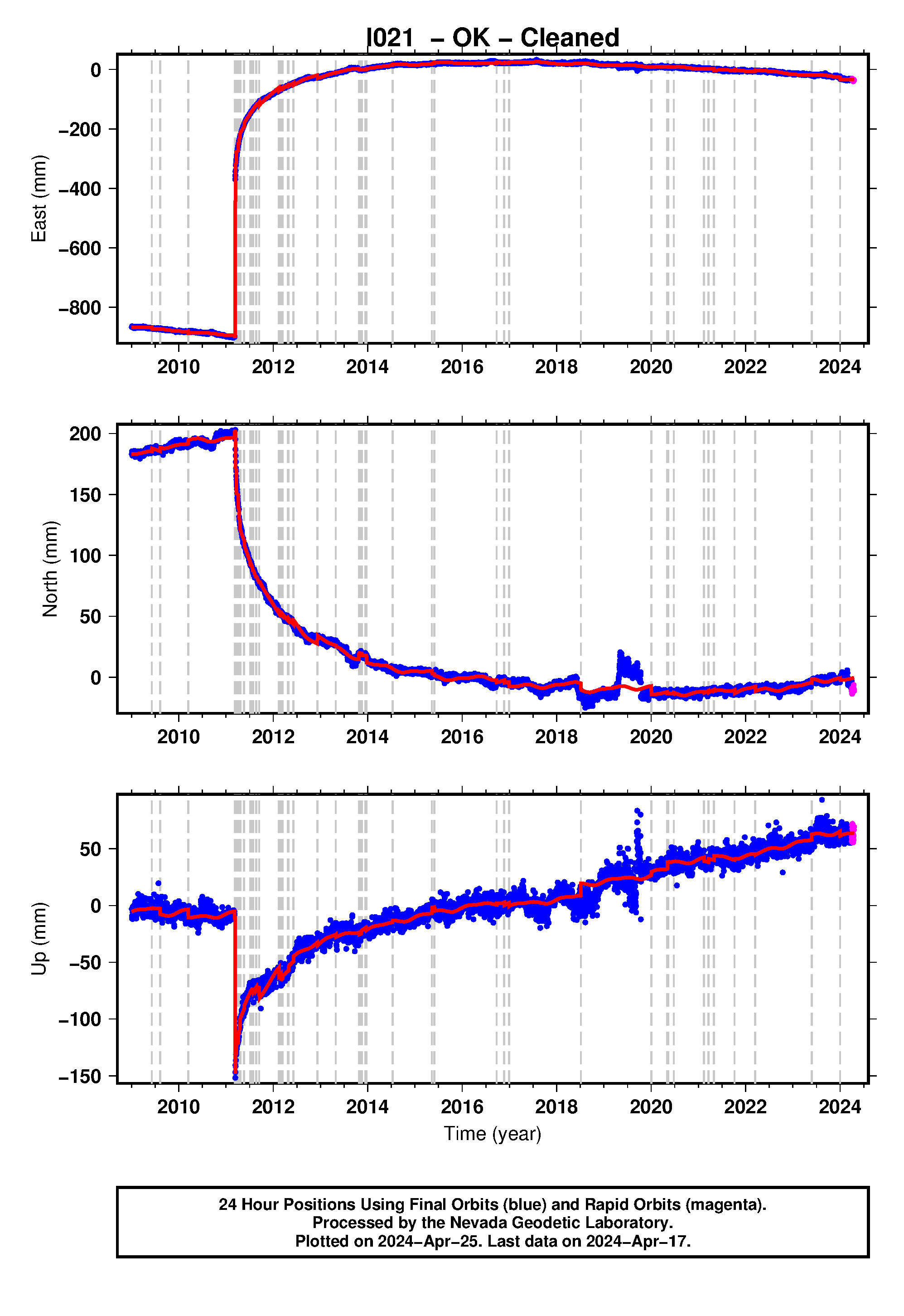
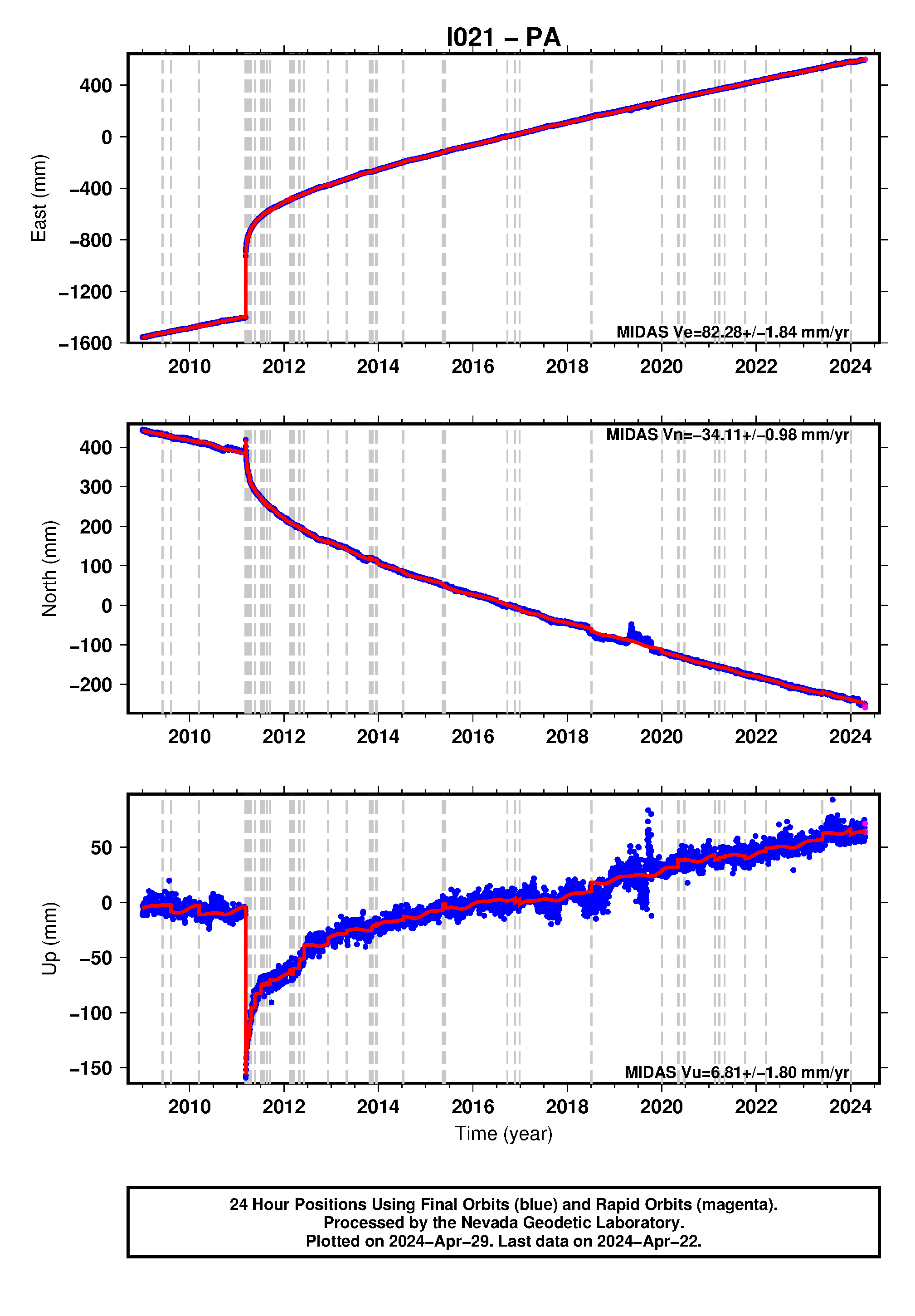
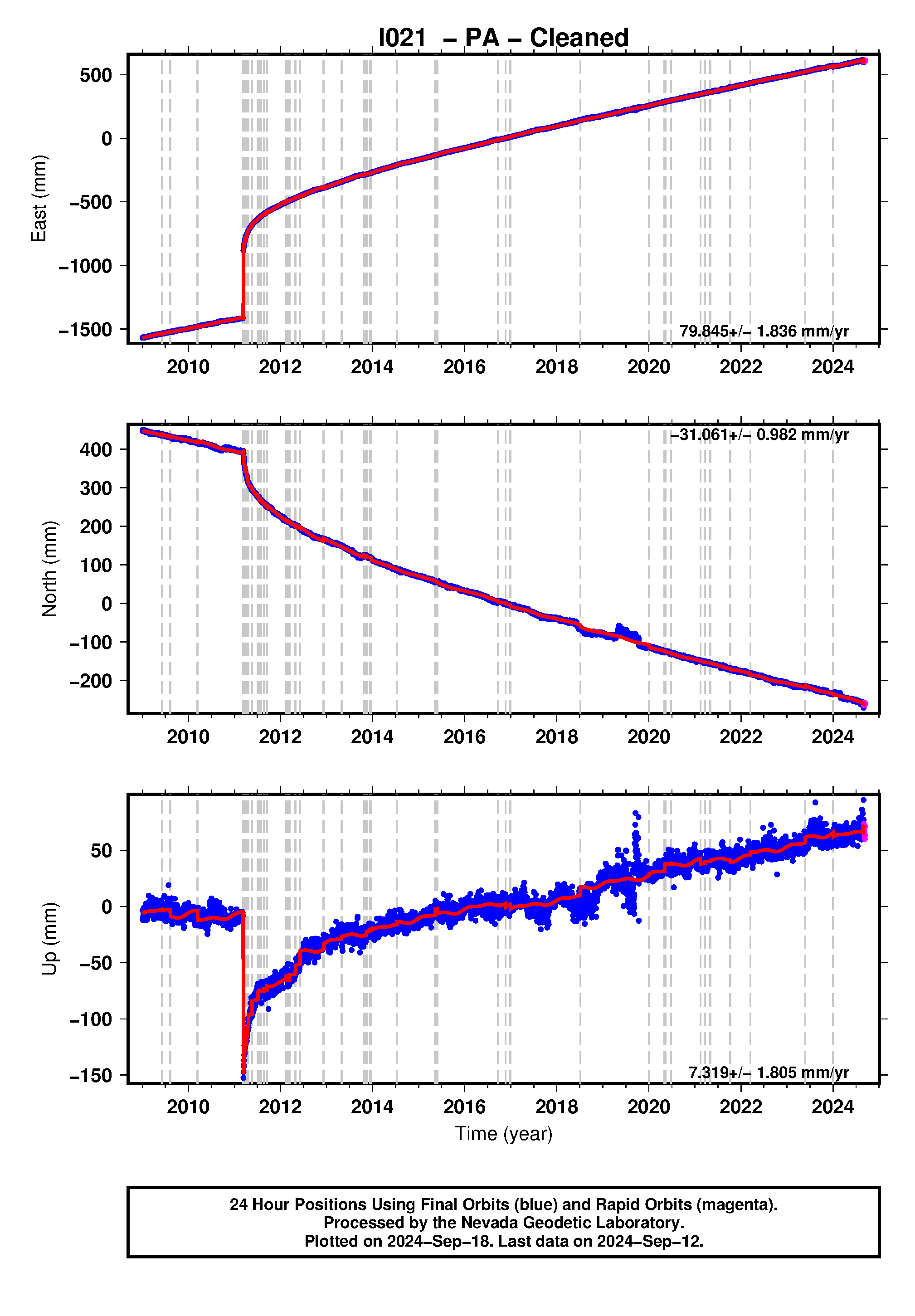
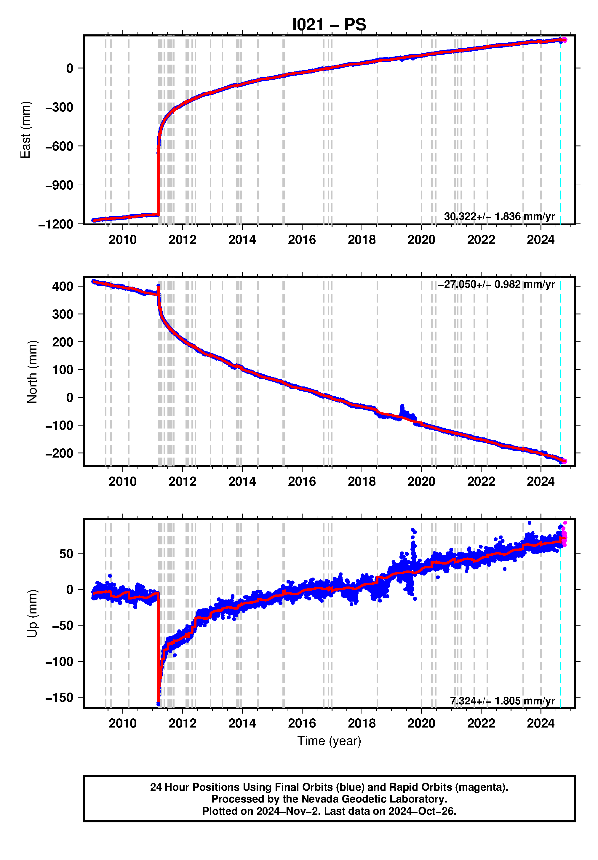
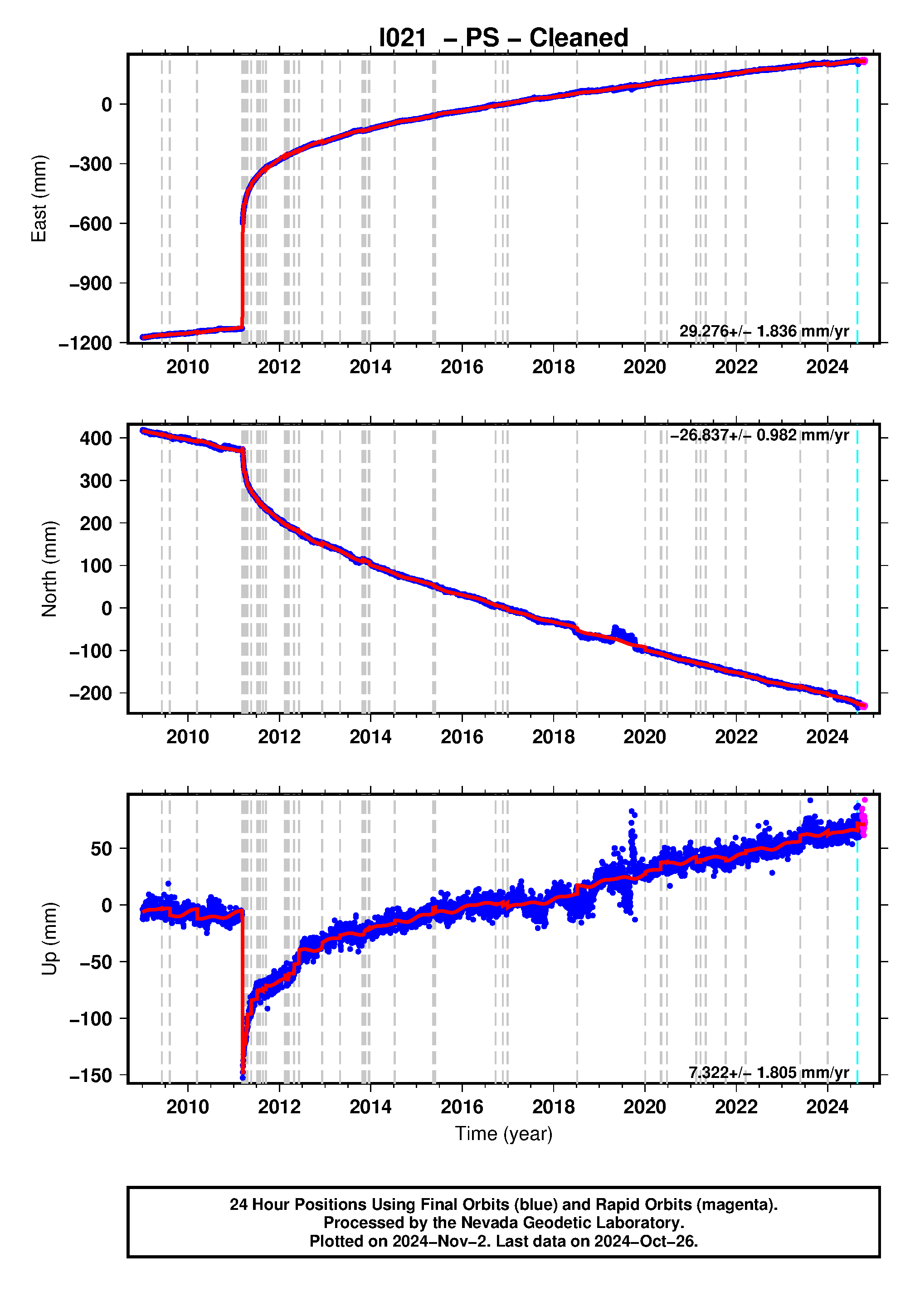
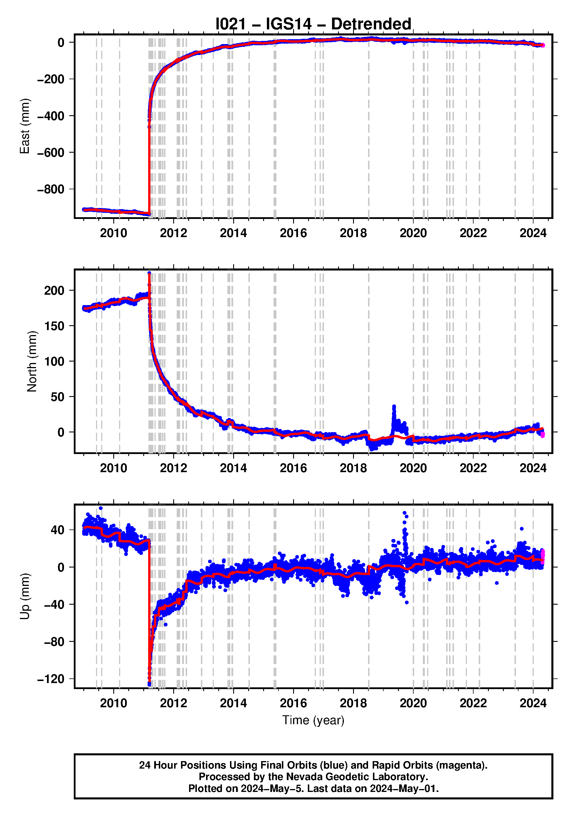
Click on the buttons on the left below to choose from available reference frames, latencies, and sample rates. Original, Cleaned (outlier removed) and detrended (using MIDAS rate) plots are available. See plot explanation page for further explanations on plot contents.
Steps Information for this station |
||||
|---|---|---|---|---|
| Station ID | Date (YYMMMDD) | Equipment Change Type/ or Event ID | Earthquake Magnitude | Distance (km) |
| I021 | 09JUN06 | usp000gxx2 | 5.8 | 40.7 |
| I021 | 09AUG09 | usp000h04j | 7.1 | 381.6 |
| I021 | 10MAR14 | usp000h9cg | 6.5 | 234.4 |
| I021 | 11MAR09 | usp000hvhj | 7.3 | 353.8 |
| I021 | 11MAR11 | official20110311054624120_30 | 9.1 | 319.3 |
| I021 | 11MAR11 | usp000hvnv | 6.3 | 220.4 |
| I021 | 11MAR11 | usp000hvp0 | 5.9 | 131.9 |
| I021 | 11MAR11 | usp000hvp2 | 5.8 | 121.4 |
| I021 | 11MAR11 | usp000hvp4 | 6.4 | 131.5 |
| I021 | 11MAR11 | usp000hvp6 | 5.9 | 101.4 |
| I021 | 11MAR11 | usp000hvp8 | 6.2 | 180.8 |
| I021 | 11MAR11 | usp000hvpa | 7.9 | 69.9 |
| I021 | 11MAR11 | usp000hvpc | 6.6 | 148.6 |
| I021 | 11MAR11 | usp000hvpd | 6.5 | 130.4 |
| I021 | 11MAR11 | usp000hvpg | 7.7 | 432.6 |
| I021 | 11MAR11 | usp000hvpm | 5.8 | 41.0 |
| I021 | 11MAR11 | usp000hvpp | 5.8 | 98.2 |
| I021 | 11MAR11 | usp000hvq3 | 6.0 | 21.8 |
| I021 | 11MAR11 | usp000hvqf | 6.3 | 138.7 |
| I021 | 11MAR11 | usp000hvqk | 6.1 | 157.0 |
| I021 | 11MAR11 | usp000hvqv | 5.8 | 114.7 |
| I021 | 11MAR11 | usp000hvr9 | 5.6 | 59.6 |
| I021 | 11MAR11 | usp000hvra | 6.2 | 115.9 |
| I021 | 11MAR11 | usp000hvrd | 6.5 | 93.0 |
| I021 | 11MAR11 | usp000hvrj | 5.6 | 41.6 |
| I021 | 11MAR11 | usp000hvrp | 5.6 | 47.9 |
| I021 | 11MAR11 | usp000hvst | 5.5 | 87.3 |
| I021 | 11MAR11 | usp000hvug | 5.7 | 27.8 |
| I021 | 11MAR11 | usp000hvux | 5.8 | 53.5 |
| I021 | 11MAR11 | usp000hvvw | 5.6 | 95.3 |
| I021 | 11MAR11 | usp000hvwz | 5.5 | 39.8 |
| I021 | 11MAR11 | usp000hvxs | 5.8 | 71.1 |
| I021 | 11MAR11 | usp000hvy0 | 6.3 | 107.3 |
| I021 | 11MAR11 | usp000hvy2 | 6.0 | 129.3 |
| I021 | 11MAR11 | usp000hvy3 | 5.5 | 82.8 |
| I021 | 11MAR11 | usp000hvzr | 5.5 | 83.6 |
| I021 | 11MAR11 | usp000hw0q | 5.8 | 101.1 |
| I021 | 11MAR11 | usp000hw1a | 5.5 | 58.2 |
| I021 | 11MAR11 | usp000hw1j | 5.5 | 10.3 |
| I021 | 11MAR11 | usp000hw2f | 5.7 | 86.5 |
| I021 | 11MAR12 | usp000hw7r | 6.5 | 269.5 |
| I021 | 11MAR12 | usp000hw8u | 5.9 | 65.8 |
| I021 | 11MAR12 | usp000hwfv | 6.1 | 169.9 |
| I021 | 11MAR13 | usp000hwq6 | 6.1 | 89.6 |
| I021 | 11MAR13 | usp000hwyc | 5.6 | 80.7 |
| I021 | 11MAR14 | usp000hx1e | 5.5 | 73.6 |
| I021 | 11MAR15 | usp000hxdx | 5.7 | 70.6 |
| I021 | 11MAR16 | usp000hxf1 | 5.7 | 6.6 |
| I021 | 11MAR17 | usp000hxnv | 5.5 | 33.0 |
| I021 | 11MAR17 | usp000hxny | 5.8 | 119.8 |
| I021 | 11MAR22 | usp000hy7j | 5.7 | 71.1 |
| I021 | 11MAR22 | usp000hy8x | 5.7 | 88.7 |
| I021 | 11MAR22 | usp000hy9e | 5.9 | 81.4 |
| I021 | 11MAR22 | usp000hy9m | 5.6 | 83.0 |
| I021 | 11APR07 | usp000hzf6 | 7.1 | 290.1 |
| I021 | 11APR11 | usp000hzq8 | 6.6 | 137.8 |
| I021 | 11APR11 | usp000hzsk | 6.2 | 40.6 |
| I021 | 11APR14 | usp000hzxk | 5.7 | 114.1 |
| I021 | 11APR21 | usp000j0c3 | 6.2 | 37.9 |
| I021 | 11MAY20 | usp000j1v8 | 5.8 | 17.8 |
| I021 | 11MAY21 | usp000j1zc | 5.6 | 24.4 |
| I021 | 11JUL06 | usp000j48b | 5.7 | 109.5 |
| I021 | 11JUL10 | usp000j4gp | 7.0 | 342.2 |
| I021 | 11JUL25 | usp000j5fr | 5.6 | 61.8 |
| I021 | 11JUL30 | usp000j5rk | 6.3 | 132.4 |
| I021 | 11AUG22 | usp000j6v4 | 5.9 | 99.7 |
| I021 | 11SEP15 | usp000j82k | 6.1 | 81.8 |
| I021 | 12FEB14 | usp000jex0 | 5.5 | 82.2 |
| I021 | 12FEB14 | usp000jex9 | 5.8 | 82.3 |
| I021 | 12FEB29 | usp000jfkt | 5.6 | 71.8 |
| I021 | 12MAR14 | usp000jg80 | 6.0 | 10.9 |
| I021 | 12APR24 | usp000jjhz | 5.5 | 23.4 |
| I021 | 12APR29 | usp000jjs6 | 5.8 | 33.6 |
| I021 | 12JUN05 | usp000jmcv | 6.1 | 102.7 |
| I021 | 12DEC07 | usp000jwjn | 7.3 | 376.2 |
| I021 | 13APR29 | usb000ghg0 | 5.6 | 31.1 |
| I021 | 13OCT25 | usc000kn4n | 7.1 | 390.3 |
| I021 | 13NOV09 | usb000kvca | 5.6 | 63.1 |
| I021 | 13NOV16 | usb000kzuj | 5.5 | 48.6 |
| I021 | 13DEC14 | usc000lkgy | 5.5 | 13.7 |
| I021 | 13DEC21 | usc000lpah | 5.5 | 19.0 |
| I021 | 14JUL11 | usb000rs50 | 6.5 | 211.6 |
| I021 | 15MAY12 | us20002et4 | 6.8 | 368.8 |
| I021 | 15MAY30 | us20002ki3 | 7.8 | 882.9 |
| I021 | 16SEP23 | us10006rte | 6.2 | 171.8 |
| I021 | 16NOV21 | us10007b88 | 6.9 | 191.4 |
| I021 | 16DEC28 | us10007naf | 5.9 | 121.8 |
| I021 | 18JUL07 | us2000fz0q | 5.9 | 74.5 |
| I021 | 20JAN02 | us70006ttf | 5.7 | 54.4 |
| I021 | 20MAY04 | us700099s8 | 5.6 | 22.9 |
| I021 | 20MAY10 | us70009dus | 5.8 | 77.6 |
| I021 | 20JUN24 | us7000aabt | 5.9 | 51.5 |
| I021 | 21FEB13 | us6000dher | 7.1 | 238.9 |
| I021 | 21MAR20 | us7000dl6y | 7.0 | 310.3 |
| I021 | 21MAY01 | us7000dz5t | 6.9 | 282.3 |
| I021 | 21OCT07 | us6000fsl6 | 5.9 | 56.8 |
| I021 | 22MAR16 | us6000h519 | 7.3 | 230.7 |
| I021 | 23MAY26 | us7000k46f | 6.1 | 29.6 |
| I021 | 24JAN01 | us6000m0xl | 7.5 | 356.2 |
| Distance is from this station to earthquake epicenter in km. A potential step record appears when this distance is less than 10^(M/2 - 0.79) where M is earthquake magnitude. | ||||
| Steps for all stations are given in the master step file database. | ||||

![]()