
|
|||||||||||||||||||||||||||||||||||||||||||||||||||||||||||||||||||||||||||||||||||||||||||||
|
|
||||||||||||||||||||||||||||||||||||||||||||||||||||||||||||||||||||||||||||||||||||||||||||
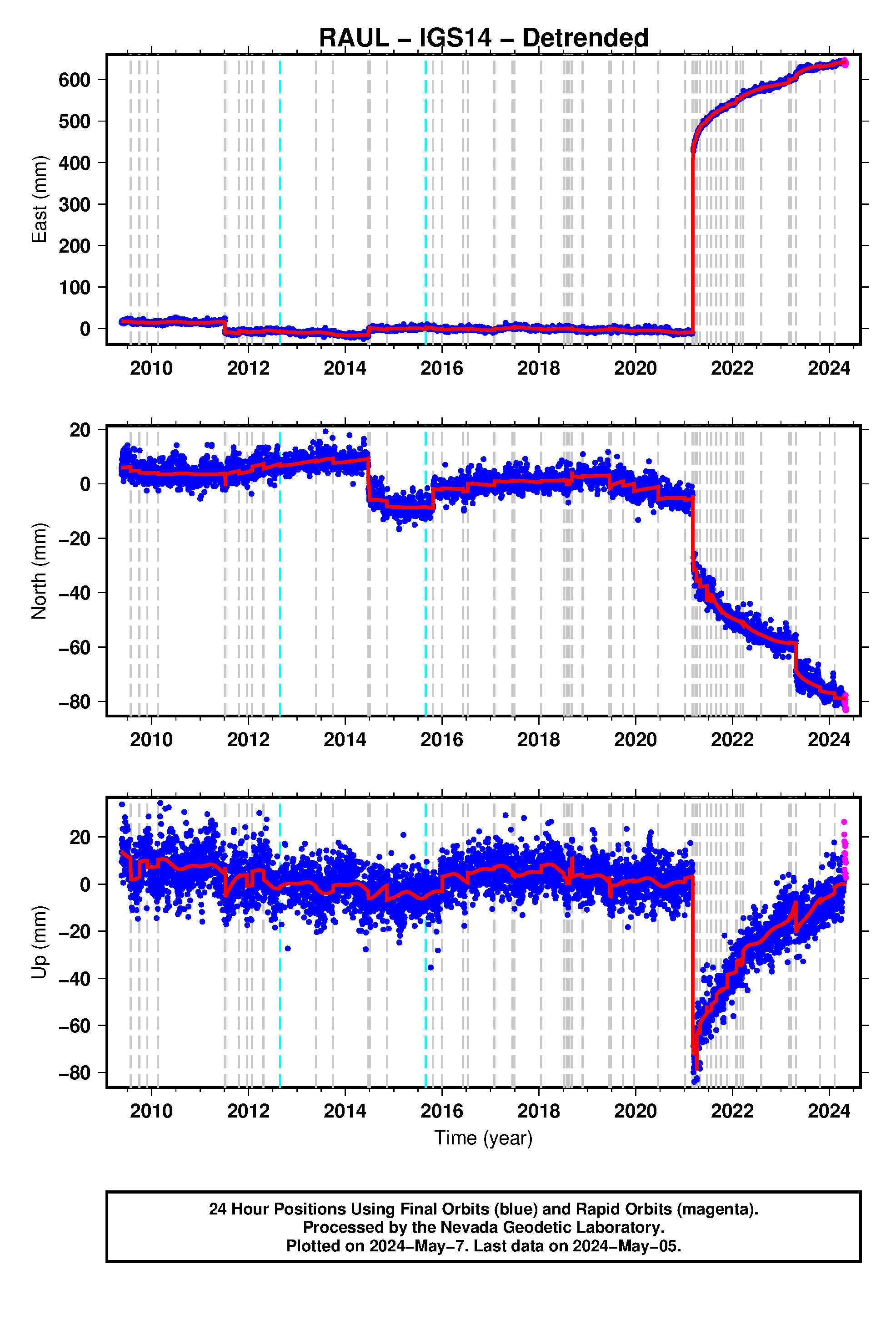
Click on the buttons on the left below to choose from available reference frames, latencies, and sample rates. Original, Cleaned (outlier removed) and detrended (using MIDAS rate) plots are available. See plot explanation page for further explanations on plot contents.

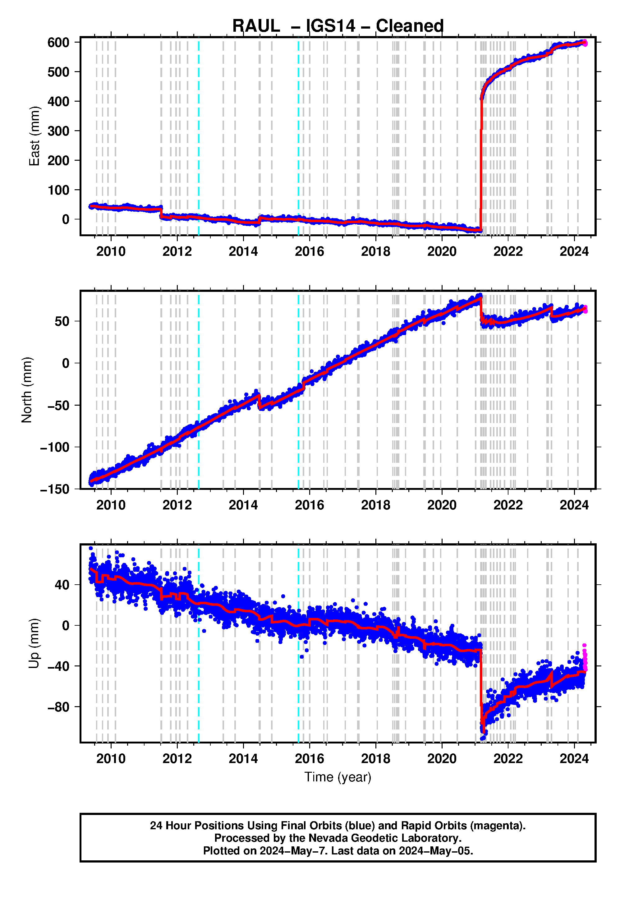
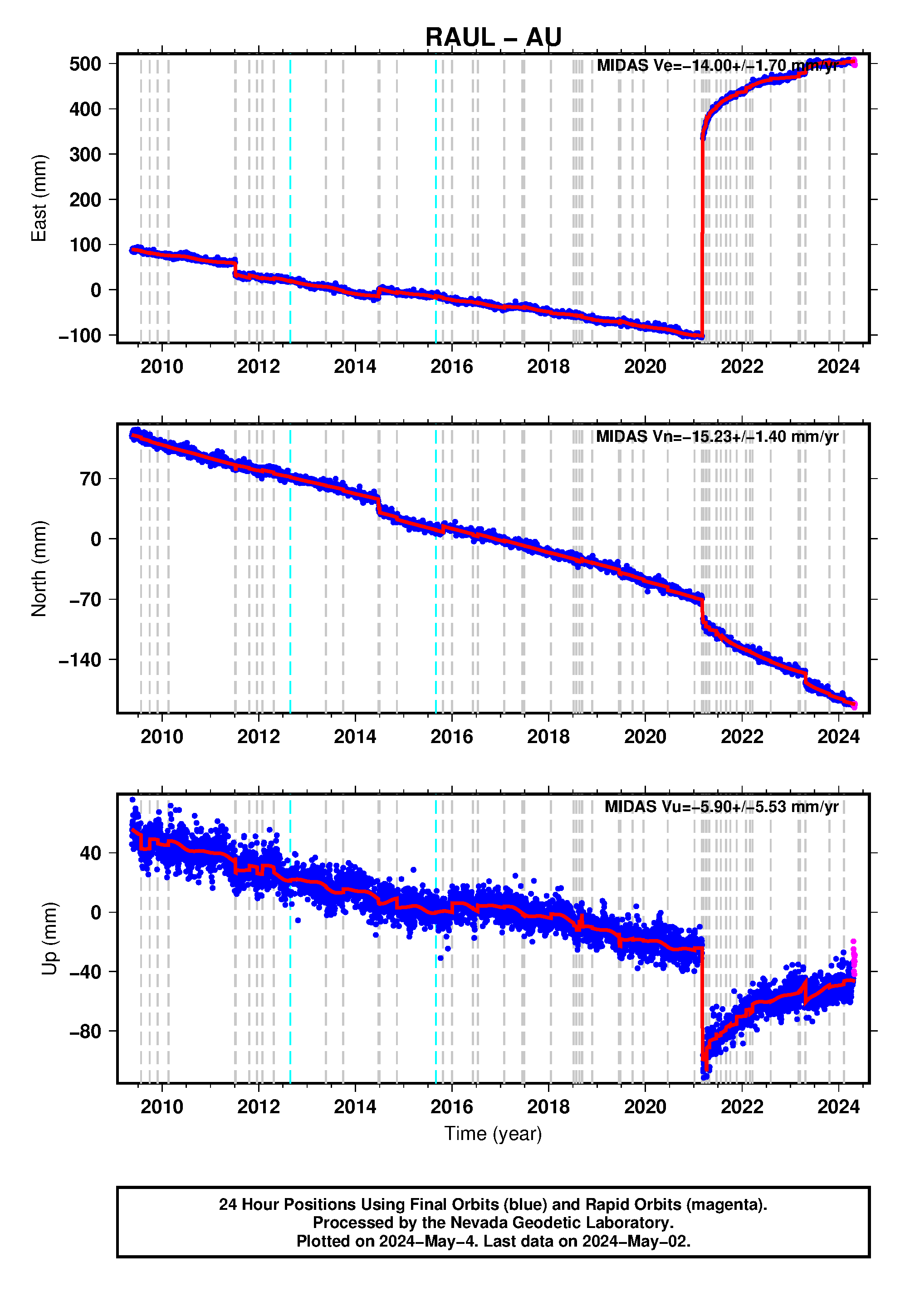

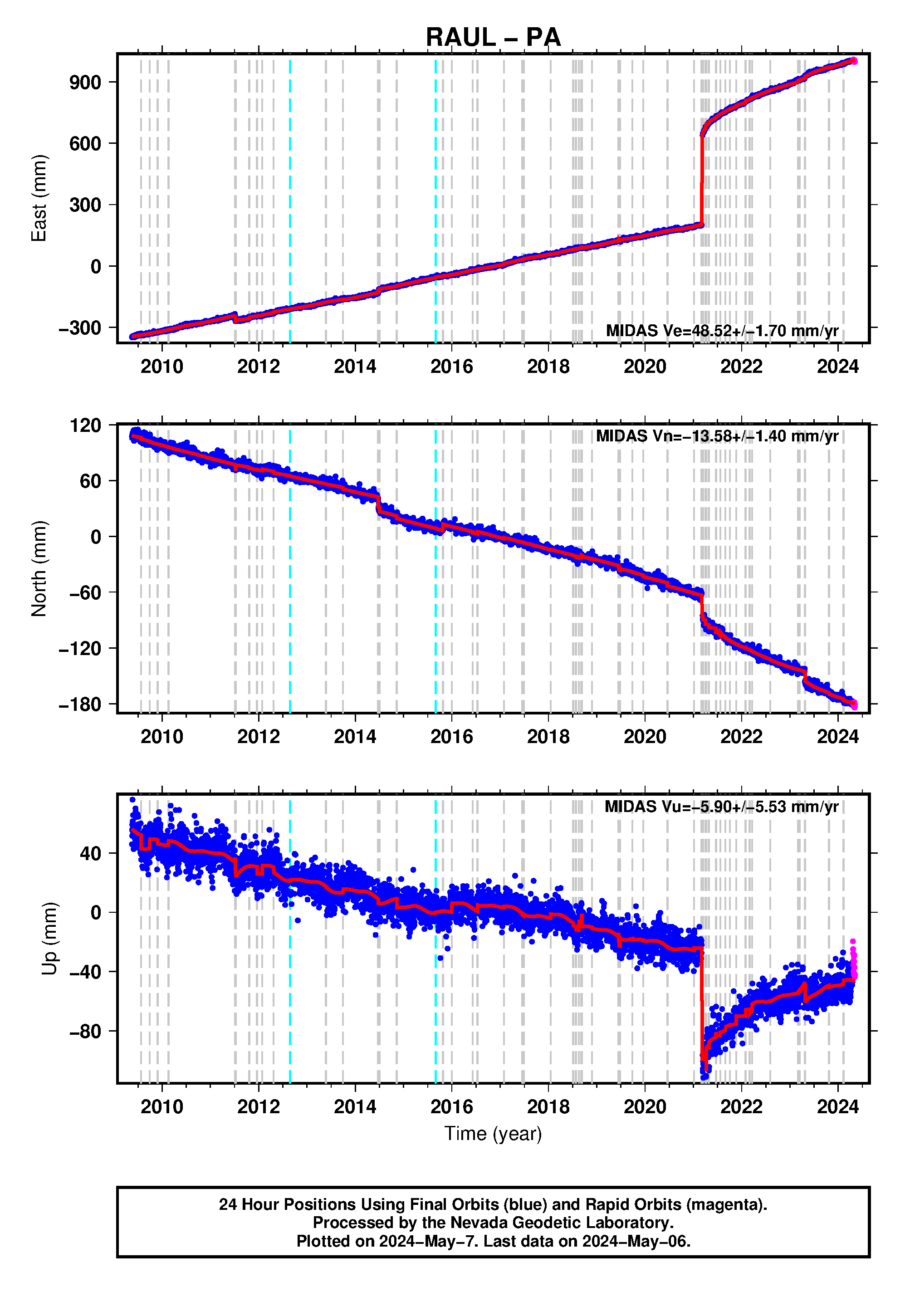
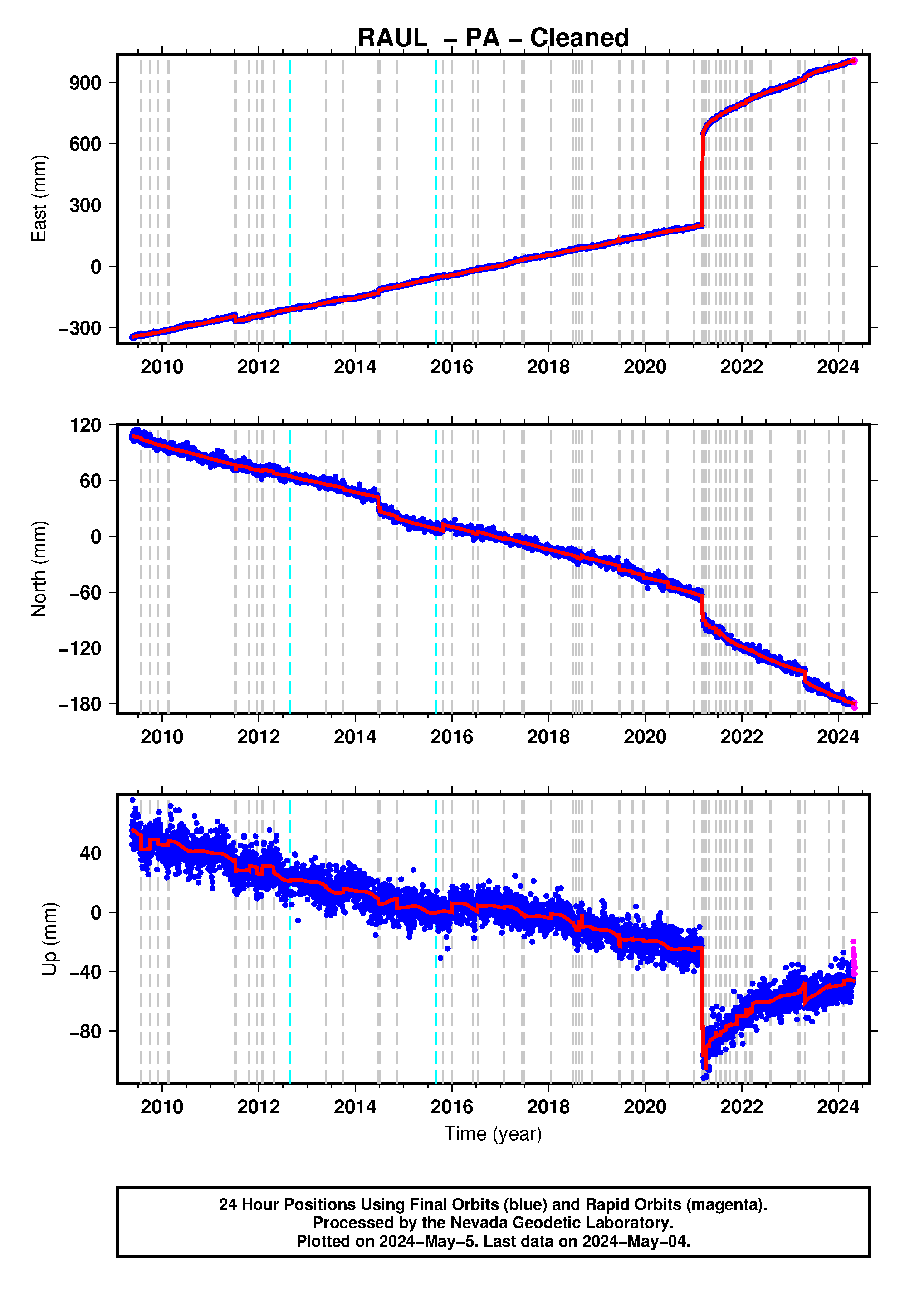
Steps Information for this station |
||||
|---|---|---|---|---|
| Station ID | Date (YYMMMDD) | Equipment Change Type/ or Event ID | Earthquake Magnitude | Distance (km) |
| RAUL | 12AUG26 | Elevation_Cutoff_Changed | - | - |
| RAUL | 15AUG31 | Elevation_Cutoff_Changed | - | - |
| RAUL | 09JUL25 | usp000gzmg | 5.6 | 63.1 |
| RAUL | 09SEP29 | usp000h1ys | 8.1 | 1642.2 |
| RAUL | 09NOV28 | usp000h4ha | 6.0 | 88.5 |
| RAUL | 10FEB17 | usp000h7dc | 5.9 | 57.6 |
| RAUL | 11JUL06 | usp000j48h | 7.6 | 157.4 |
| RAUL | 11JUL07 | usp000j4ac | 5.8 | 96.3 |
| RAUL | 11JUL09 | usp000j4ew | 5.9 | 80.1 |
| RAUL | 11JUL09 | usp000j4f4 | 6.0 | 85.8 |
| RAUL | 11JUL09 | usp000j4fs | 6.0 | 91.9 |
| RAUL | 11JUL11 | usp000j4m9 | 5.9 | 133.6 |
| RAUL | 11OCT21 | usp000j9nm | 7.4 | 166.6 |
| RAUL | 11DEC19 | usp000jccy | 5.7 | 105.2 |
| RAUL | 12JAN28 | usp000je36 | 5.9 | 56.5 |
| RAUL | 12APR23 | usp000jjfr | 6.0 | 91.6 |
| RAUL | 13MAY23 | usb000h3k3 | 7.4 | 696.9 |
| RAUL | 13SEP30 | usb000k2h2 | 6.5 | 190.7 |
| RAUL | 14JUN23 | usc000rkg5 | 6.9 | 83.8 |
| RAUL | 14JUN23 | usc000rkga | 6.5 | 86.8 |
| RAUL | 14JUN23 | usc000rkhj | 6.7 | 83.5 |
| RAUL | 14JUN23 | usc000rkn2 | 5.9 | 103.8 |
| RAUL | 14JUL03 | usc000rqbg | 6.3 | 196.8 |
| RAUL | 14NOV10 | usc000sw4e | 5.7 | 89.0 |
| RAUL | 15OCT25 | us10003rbc | 5.8 | 16.2 |
| RAUL | 16JAN01 | us10004aqy | 5.8 | 93.2 |
| RAUL | 16JUN06 | us2000629f | 6.1 | 87.1 |
| RAUL | 16JUL13 | us1000638m | 6.3 | 200.1 |
| RAUL | 17JAN29 | us10007w1e | 5.9 | 105.0 |
| RAUL | 17JUN15 | us20009mjp | 6.0 | 141.9 |
| RAUL | 17JUN28 | us20009q4v | 6.0 | 121.3 |
| RAUL | 18JAN17 | us2000ckj1 | 5.8 | 88.6 |
| RAUL | 18JUL07 | us2000fzb7 | 6.0 | 147.6 |
| RAUL | 18JUL28 | us2000gg23 | 5.7 | 101.2 |
| RAUL | 18AUG19 | us1000gcii | 8.2 | 1238.0 |
| RAUL | 18SEP06 | us2000h9e2 | 7.9 | 1229.0 |
| RAUL | 18SEP10 | us2000hbpv | 6.9 | 310.5 |
| RAUL | 18NOV25 | us1000hwb5 | 5.6 | 65.1 |
| RAUL | 19JUN15 | us6000417i | 7.3 | 156.5 |
| RAUL | 19JUN16 | us600041b3 | 6.3 | 195.8 |
| RAUL | 19JUN19 | us600042vn | 6.4 | 142.5 |
| RAUL | 19JUN21 | us6000444m | 6.2 | 184.9 |
| RAUL | 19JUN27 | us700045vh | 6.3 | 176.1 |
| RAUL | 19SEP27 | us70005mea | 6.1 | 103.5 |
| RAUL | 19DEC18 | us60006szl | 5.9 | 78.5 |
| RAUL | 20JUN18 | us6000ae4n | 7.4 | 450.2 |
| RAUL | 21JAN06 | us6000d5zz | 6.2 | 93.2 |
| RAUL | 21MAR04 | us7000dfk3 | 7.4 | 48.8 |
| RAUL | 21MAR04 | us7000dflf | 8.1 | 82.3 |
| RAUL | 21MAR04 | us7000dhr8 | 5.6 | 92.2 |
| RAUL | 21MAR04 | us7000dfm1 | 5.7 | 58.4 |
| RAUL | 21MAR04 | us7000dfmf | 6.1 | 153.9 |
| RAUL | 21MAR04 | us7000dhu0 | 5.8 | 79.7 |
| RAUL | 21MAR04 | us7000dfp1 | 5.8 | 118.0 |
| RAUL | 21MAR04 | us7000dfq2 | 6.5 | 146.1 |
| RAUL | 21MAR04 | us7000dfqh | 5.6 | 80.9 |
| RAUL | 21MAR05 | us7000dfr3 | 5.5 | 82.3 |
| RAUL | 21MAR05 | us7000dfrf | 5.9 | 136.5 |
| RAUL | 21MAR05 | us7000dft1 | 6.3 | 144.3 |
| RAUL | 21MAR05 | us7000dfz4 | 6.2 | 133.9 |
| RAUL | 21MAR05 | us7000dg5d | 5.8 | 98.8 |
| RAUL | 21MAR05 | us7000dg5e | 5.7 | 113.4 |
| RAUL | 21MAR06 | us7000dgd9 | 5.8 | 85.8 |
| RAUL | 21MAR06 | us7000dgdc | 6.1 | 113.5 |
| RAUL | 21MAR06 | us7000dgdw | 5.5 | 88.8 |
| RAUL | 21MAR06 | us7000dggf | 6.2 | 92.9 |
| RAUL | 21MAR06 | us7000dgh7 | 6.2 | 98.9 |
| RAUL | 21MAR06 | us7000dgi0 | 6.1 | 110.2 |
| RAUL | 21MAR06 | us7000dgp3 | 5.6 | 96.8 |
| RAUL | 21MAR07 | us7000dgze | 5.8 | 107.0 |
| RAUL | 21MAR13 | us7000dj39 | 5.9 | 68.8 |
| RAUL | 21APR01 | us6000dy64 | 6.4 | 83.3 |
| RAUL | 21APR01 | us6000dydn | 5.6 | 97.4 |
| RAUL | 21APR06 | us6000dzd6 | 5.7 | 100.9 |
| RAUL | 21APR07 | us6000dzlv | 6.1 | 129.7 |
| RAUL | 21APR27 | us7000dxxy | 5.9 | 105.8 |
| RAUL | 21APR29 | us7000dygd | 6.1 | 156.3 |
| RAUL | 21APR29 | us7000dyh1 | 5.5 | 90.6 |
| RAUL | 21JUN20 | us7000eeq4 | 6.5 | 108.3 |
| RAUL | 21JUN21 | us7000eewi | 5.9 | 114.0 |
| RAUL | 21JUL24 | us6000eynb | 6.1 | 127.9 |
| RAUL | 21AUG31 | us7000f60j | 6.4 | 92.1 |
| RAUL | 21OCT04 | us6000frhs | 5.7 | 91.5 |
| RAUL | 21NOV21 | us7000fvvz | 5.8 | 105.3 |
| RAUL | 22JAN29 | us7000gg3w | 6.5 | 122.2 |
| RAUL | 22JAN29 | us7000gg4u | 5.8 | 102.3 |
| RAUL | 22JAN31 | us7000ggkz | 5.7 | 96.8 |
| RAUL | 22JAN31 | us7000gglh | 5.9 | 114.8 |
| RAUL | 22MAR02 | us6000h1d2 | 6.6 | 94.4 |
| RAUL | 22MAR20 | us6000h67z | 6.0 | 85.9 |
| RAUL | 22AUG05 | us6000i89c | 5.8 | 121.3 |
| RAUL | 23MAR04 | us7000jh99 | 6.9 | 88.8 |
| RAUL | 23MAR16 | us7000jkbd | 7.0 | 196.0 |
| RAUL | 23APR24 | us6000k6mg | 7.1 | 79.7 |
| RAUL | 23APR24 | us6000k6mz | 5.5 | 64.0 |
| RAUL | 23OCT23 | us6000lhgd | 6.0 | 89.5 |
| RAUL | 24FEB09 | us7000lxyv | 6.1 | 101.4 |
| RAUL | 24MAY31 | us7000mp9e | 6.2 | 108.1 |
| RAUL | 24JUL25 | us6000nfjw | 5.7 | 110.7 |
| RAUL | 24AUG09 | us6000nj2k | 5.9 | 132.0 |
| RAUL | 24AUG25 | Temporary_Step_JPL_Product_Change | - | - |
| Distance is from this station to earthquake epicenter in km. A potential step record appears when this distance is less than 10^(M/2 - 0.79) where M is earthquake magnitude. | ||||
| Steps for all stations are given in the master step file database. | ||||

![]()