

|
|
|
|
300th Anniversary of the Magnitude 9 Cascadia Earthquake At 9 p.m. on Jan. 26, 1700, the undersea Cascadia thrust fault ruptured along a 1,000 - kilometre length from mid-Vancouver Island to northern California in a great earthquake, producing tremendous shaking and a huge tsunami that swept across the Pacific ocean. The Cascadia fault is the boundary between two of the earth's tectonic plates: the smaller offshore Juan de Fuca plate is sliding under the much larger North American plate. The earthquake collapsed houses of the Cowichan people on Vancouver Island and caused numerous landslides. The shaking was so violent that people could not stand and so prolonged that it made them sick. On the west coast of Vancouver Island, the tsunami destroyed the winter village of the Pachena Bay people, leaving no survivors. These events are recorded in the oral traditions of the First Nations people on Vancouver Island. The tsunami also caused destruction along the Pacific coast of Japan. It is the accurate descriptions of the tsunami and the precise time-keeping by the Japanese that allow us to know the size and the exact time of this great earthquake. 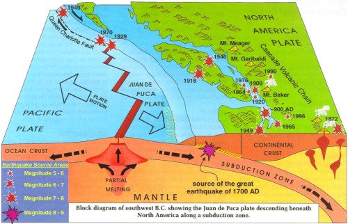 Graphic from the Geological Survey of Canada The quake also left unmistakable signatures in the geological record as the outer coastal regions subsided and drowned coastal marshlands and forests that were then covered with younger sediments. The recognition of definitive signatures in the geological record shows this earthquake was not a unique event, but has been repeated many times at irregular intervals of hundreds of years. Geological evidence indicates that 13 great earthquakes have occurred in the last 6,000 years. A similar offshore event will happen sometime in the future and is a considerable hazard to those who live in southwestern B.C. However, because the fault is offshore, it is not the greatest earthquake hazard faced by major West Coast cities. In the interval between great earthquakes, the tectonic plates become stuck together, yet continue to move towards each other. This causes tremendous strain and deformation of the earth's crust in the coastal region and causes ongoing earthquake activity. This is the current situation. Some onshore earthquakes can be quite large (there have been four magnitude 7+ earthquakes in the past 130 years in southwestern B.C. and northern Washington State). Because these inland earthquakes can be much closer to urban areas and occur more frequently, they represent the greatest earthquake hazard. An inland magnitude 6.9 earthquake in 1995 in a similar geological setting beneath Kobe, Japan, caused more than $200 billion damage. For more information: On the great Cascadia earthquake or earthquake hazard: visit the Geological Survey of Canada (GSC) Web site at http://www.pgc.nrcan.gc.ca or telephone the GSC at (250) 363-6500. On tsunamis: visit the Canadian Hydrographic Service (CHS) Web site at http://www.ios.bc.ca/ios/chs/tides/TIDES1.htm or telephone the CHS at (250) 363-6350. On preparedness for earthquakes and tsunamis: visit the Provincial Emergency Program (PEP) Web site preparedness pages or check the red-tabbed pages in the front of your British Columbia Telus telephone book. For more detailed information on preparedness contact PEP at 1-800-663-3456, or Emergency Preparedness Canada at (250) 363-3621. |